
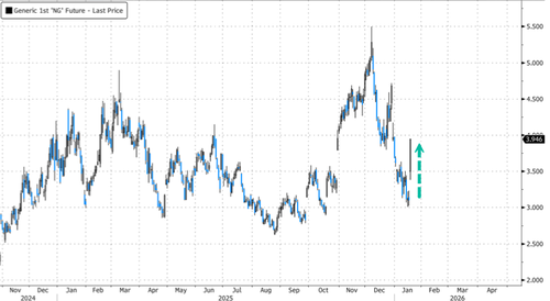
US natural gas futures surged for a second straight session as an Arctic cold blast and mounting winter storm threats forced traders to reassess energy demand, with heating demand across much of the eastern US now forecast to surge sharply.
As of 09:00 ET, NatGas futures are up nearly 27%, marking the largest intraday jump since Russia’s invasion of Ukraine in late January 2022. The move comes as weather models flipped sharply colder, now forecasting a massive deep freeze across the eastern half of the country through the end of the month.
NatGas prices are set to reclaim the $4 per mmbtu level.
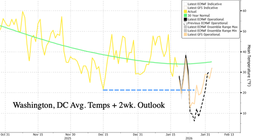
Average temperatures across Washington, DC, are plunging and could average around 10°F by the weekend. This cold blast is far more extreme than the one in the first half of December. Notably, this period typically coincides with the most intense part of winter.
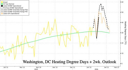
The cold blast has sent the heating demand forecast for the next two weeks through the roof.
More details on the cold blast:
-
A colder outlook indicates a higher heating demand that would erase the modest storage surplus seen earlier this month.
-
Hedge funds had increased bearish bets last week, leaving the market vulnerable to a short-covering rally once forecasts changed.
-
Forecasters at Atmospheric G2 said earlier that weather models underestimated both the intensity and the geographic reach of the Arctic cold.
-
Commodity Weather Group expects average temperatures around 8°F below normal across much of the Midwest, Mid-Atlantic, and parts of southern New England through this weekend.
-
The US Weather Prediction Center warned two dozen weather stations could break or tie daily temperature records through Jan. 26.
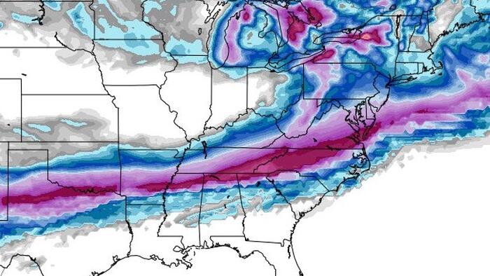
Among meteorologists on X, discussion has abruptly shifted toward what could become a historic winter storm stretching from Texas to the Mid-Atlantic, beginning Friday. Weather observer Ryan Hall detailed this winter threat in a report Monday titled “This Could Be The Big One.”
Here’s what meteorologists are saying:
On Sunday morning, snow and ice is forecast to stretch 2,000 miles from the Southwest to the East Coast.
Around 160 million people are forecast to experience wintry precipitation simultaneously!
Here’s a sampling of possible precipitation types in some cities early Sunday:… pic.twitter.com/L0scgoZJv7
— Ben Noll (@BenNollWeather) January 20, 2026
Odds are increasing for a particularly memorable winter storm late this week into the weekend… pic.twitter.com/fopHLEj40G
— Ryan Hall, Y’all (@ryanhallyall) January 20, 2026
⚠️A potentially historic winter storm is gearing up for weekend impact across a large portion of the country.
I’ll be live with in-depth analysis to Clarity clients at 7am est.
To access our platform and our client lives you can by signing up now: https://t.co/5NjlJjOeSS pic.twitter.com/5xkF0JvQFf
— BAM Weather (@bam_weather) January 20, 2026
All eyes are on the Mid-Atlantic late this week as winter storm threats rise.
Loading recommendations…