
Winter in the Mid-Atlantic region is certainly winding down, and March is always an unpredictable month. Early next week, a fast-moving Alberta Clipper is forecast to bring yet another round of wintry weather to the region before a spring warm-up arrives by mid-month.
Marko Korosec, lead forecaster at SWE, wrote in a new weather note that the Alberta Clipper is set to spread snow, ice, and freezing rain from the Midwest to the Mid-Atlantic beginning Sunday and continuing through Tuesday.
Korosec continued:
A new winter storm will set the stage for another snowstorm event early next week, with a new pack of snow that will blanket areas recently impacted by the storm Hernando.
From Sunday through Tuesday, a fast-moving Alberta Clipper winter storm will race from the Midwest to the Mid-Atlantic, travelling along the southward-surgeing frigid Arctic cold pool, beneath the southern lobe of the Polar Vortex aloft.
The Clipper storm is a system fueled by a fresh surge of Arctic air mass diving south from Canada into the U.S. These storms typically form in the lee of the Canadian Rockies (Alberta) and quickly move across the northern United States towards the East.
These systems are not fueled by high moisture or other winter storms, so snow amounts are less impactful but can still disrupt travel. They are followed by extreme cold air masses, characterized by a massive drop in temperature.
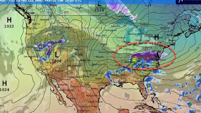
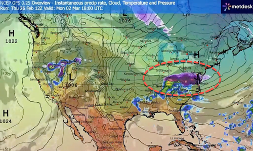
We are tracking a potentially impactful storm system that will barrel across parts of the nation this Sunday and Monday, leading to travel disruptions with a wintry mix of snow and ice. As the lobe aloft dips south, it brings another deep freeze plunging southeastward from Canada into the U.S. in the following days.
A Clipper winter storm to deliver new snow from the Midwest to the Mid-Atlantic
The storm will impact areas from Chicago and Detroit to New York City and Philadelphia, with Monday morning rush-hour travel disrupted by fresh snow and locally ice or freezing rain.
The intensifying polar jet stream will keep the Arctic high over Canada strong, locking the Great Lakes and the Northeast in a deep freeze through mid-week, resulting in cold temperatures for the first month of the meteorological spring.
Before we dig into the details of the impactful new Winter Storm, it is essential to understand the background mechanisms governing the Polar Vortex. It remains the primary driver of rapid weather changes and intense Arctic outbreaks across Canada and the United States during winter or early spring.
That’s right.
nobody wants this pic.twitter.com/4kKpnACLpx
— Max Velocity (@MaxVelocityWX) February 27, 2026
For folks in the Mid-Atlantic, this winter has been historic (see here), despite Al Gore’s broken-record global-warming pitch for the last three decades, repeated at Davos earlier this year. However, warmer weather is set to return to Washington, D.C., with temperatures in the coming weeks reaching 70°F.
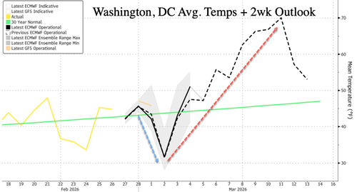
Mid-Atlantic residents may hope only for warmer weather to dial back heating demand amid the worsening power bill crisis in the region.
Loading recommendations…