

On Friday, an atmospheric river moves inland, pounding Northern and Central California with a series of moisture-packed storms. According to the National Weather Service, the mountains will experience “copious amounts of heavy snow,” while the lower elevations will experience “significant rainfall.”
NWS’ Weather Prediction Center issued an “extreme” flash flooding risk for the Southern Sierra Nevada and the central California coast range south of Monterey. The reason for this severe warning is the latest computer models, which indicate that the atmospheric river will be even warmer and wetter than previously forecasted.
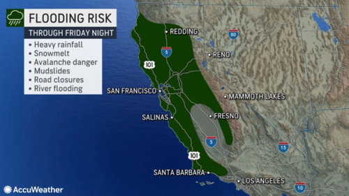
The combination of heavy rain and melting snow in certain parts of California is expected to pose a significant risk of flooding until Friday night.
Very heavy rain combined with melting snow will create a major flood risk in parts of California through Friday night: https://t.co/smONH4RjkB pic.twitter.com/6iIK9eYwQf
— Breaking Weather by AccuWeather (@breakingweather) March 10, 2023
California Gov. Gavin Newsome added 21 counties to California’s state of emergency declaration, including those in the Bay Area. Newsom also requested President Biden to declare an emergency for the region.
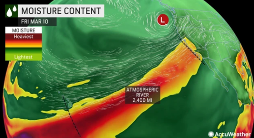
Accuweather shows the atmospheric river extends more than 2,400 miles from California to the southwest of Hawaii — this type of weather phenomenon is called a “Pineapple Express.”
Accuweather meteorologists warned:
Because above-freezing temperatures are forecast in higher elevations, the several inches to a couple of feet of snow already on the ground in intermediate elevations from 2,500 to 5,000 feet may not fully absorb the rain and could completely melt instead.
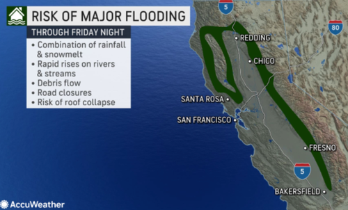
The equivalent of 8-12 inches of water could be released in a matter of hours when accounting for the moisture already locked up in the snow and the incoming several inches of rain. As this rapid runoff occurs, the smaller rivers and streams from the mountains and hills have the potential to lead to rapid flooding, which can create dangerous and damaging conditions for people, homes, businesses and other structures in the path of the raging waters.
A general 1-4 inches of rain will cause problems on area streets, highways and rural roads. Incidents of urban flooding are likely in areas from near Santa Barbara to Redding. Motorists should be prepared for road hazards ranging from high water to falling rocks and mudslides. In some severe cases, stretches of roads could be washed away.
“The torrential rain and piles of snow laying at the edges of area streets and rural roads is likely to lead to flooding,” AccuWeather Senior Meteorologist Brett Anderson said. “Where possible, road crews and property owners may want to open up the storm drains to minimize the flooding risk.”
Despite the conveyor belt of storms, AccuWeather Chief On-Air Meteorologist Bernie Rayno noted some good news for the drought situation in the state: “The rain from the storm from Thursday night to Friday night will likely wipe out most of the remaining drought across Central California.”
Loading…


