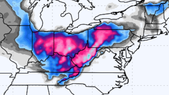
Computer models are signaling the potential for a snowstorm to develop by the end of next week, impacting areas across Ohio Valley to the Mid-Atlantic and Northeast.
“Huge storm potential next week with similarities to Nov 25 1950. Upper low bellies through with heavy midwest into Appalachians snow later next week,” meteorologist Joe Bastardi wrote on X.
Huge storm potential next week with similarities to Nov 25 1950. upper low bellies through with heavy midwest into Appalachians snow later next week pic.twitter.com/04wDmDaS4l
— The American Storm (@BigJoeBastardi) November 16, 2024
“Keeping an eye on a big time storm potential across the Ohio Valley into the mid-atlantic/northeast Wednesday into Thursday,” meteorologist Ryan Kane wrote on X.
Kane noted, “Models continue to suggest a very strong ULL. Lots snow coming for Appalachians! Will be tracking this over the next few days.”
Keeping an eye on a big time storm potential across the Ohio Valley into the mid-atlantic/northeast Wednesday into Thursday. Models continue to suggest a very strong ULL. Lots snow coming for Appalachians! Will be tracking this over the next few days. #MdWx pic.twitter.com/9s5qdB6dIl
— Ryan Kane (@ryankanerWX) November 16, 2024
He added…
6 years ago today was a classic CAD setup with heavy snow to rain across the DMV. Starting at 200mb wind, there were two UL jet streaks which set the HP in a perfect spot. At 500mb, there was a negatively tilted ULL. Sfc modeling showed a clear CAD signature. Images from PolarWX pic.twitter.com/BVVsq0UfqS
— Ryan Kane (@ryankanerWX) November 15, 2024
Here’s what others are saying about accumulating snow threats next week…
Still a LOT of uncertainty in the details of the sensible weather/snow with this system but operational models are coming into better agreement on a DEEP Great Lakes Low mid week. If you are flying out of #Chicago Wed/Thu you need to watch for delays and cancellations. pic.twitter.com/N8XPBY7ElX
— Tom Niziol (@TomNiziol) November 16, 2024
The first accumulating snow of the season is looking more likely now for parts of Western Maryland at the end of next week. Probably won’t snow around Baltimore, but ‘weird’ things happen under closed upper lows. 👇 😁 So stay tuned… #MdWx ❄️🚂 pic.twitter.com/6NW6lXC47n
— Tony Pann (@TonyPannWBAL) November 16, 2024
The 12z Canadian Model just came in with an absolutely WILD solution for Thursday! 👀💥
It produces a Bomb Cyclone near NYC with pressures dropping from 986mb to 960mb in only 12 hours on November 21st!If something like this were to actually happen, you’d see feet of snow in… pic.twitter.com/0nNNKBzHDj
— Mark Margavage (@MeteoMark) November 15, 2024
White Christmas?
Forecasted 32 day snowfall totals through Christmas Day on Euro long range. pic.twitter.com/2xFkHLpb2i
— The American Storm (@BigJoeBastardi) November 16, 2024
Lots of snow in Europe?
I do not recall seeing this much snow in Europe this early in the season. 15 day euro ensemble pic.twitter.com/HSIZ6O7meJ
— The American Storm (@BigJoeBastardi) November 15, 2024
All eyes are on the end of next week.
Loading…


